
Groundwater in Southwestern Algeria: An Essential Heritage and Keys to Development
Abstract
A regional overview describes groundwater resources in Southwestern Algeria, assessing challenges and strategies for sustainable development under climatic and demand pressures.
Author Contributions
Academic Editor: Jayanta Das, Rampurhat College
Checked for plagiarism: Yes
Review by: Single-blind
Copyright © 2023 MERZOUGUI Touhami, et al.
 This is an open-access article distributed under the terms of the Creative Commons Attribution License, which permits unrestricted use, distribution, and reproduction in any medium, provided the original author and source are credited.
Competing interests
The authors have declared that no competing interests exist.
Citation:
Introduction
Groundwater, this invisible component of the water cycle, plays a major role for man and the environment, especially in arid and hyperarid zones. It represents the only water resource for the oases of the Saoura valley.
Groundwater forms an environment that is still poorly understood, but unique. At the boundary between underground and surface, springs, wells and boreholes have always exerted a strong attraction on the human spirit. These waters are part of our heritage and must be preserved. The economic and environmental importance of groundwater makes their preservation a factor of sustainable development. Algeria's water resources are limited. They are estimated at 19.2 billion m3, including 12.4 billion m3 of surface water (mainly distributed over the northern part of the country), 1.9 billion m3 of groundwater in the North and 4.9 billion m3, exploitable in the South (PNAE-DD, 2002).
Although, in the Algerian Sahara, this resource is subject to a very unbalanced spatial and seasonal distribution: long summer dry season and very high variability of rainfall depending on the year, combined with a very high demand for water, both for agriculture, than for the concerted populations, always on the oases and some well-known cities.
Photo 1.Groundwater accumulation and recharge area (Erg Erraoui, 2019).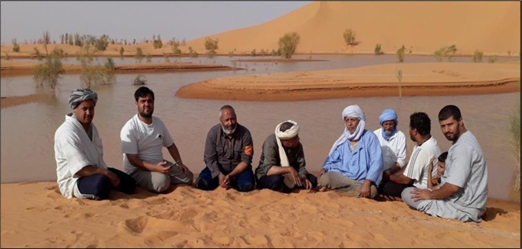
The great water towers of southern Algeria
The Algerian Sahara covers an area of more than two million square kilometers and extends from the Saharan Atlas and the Aurès to the Malian, Nigerian and Libyan, Mauritanian and Moroccan borders, a distance of more than two thousand kilometers (North -south).
Among the great water towers of the Algerian Sahara (Figure 1) we have the acquisition of the Intercalary Continental, Terminal Complex, Grand Erg Oriental and Grand Erg Occidental, attributedto the Mio-Plio-Quaternary as well as the Paleozoic. The study of groundwater recharge, paleorecharge and discharge in Western Sahara is part of a scientific issue that has not yet been fully addressed in the Western Sahara domain. The previous hydrogeological studies carried out admit that the knowledge is very fragmentary, on the aquifer systems: Northern Saha aquifer system, Bechar basin, Saoura basin, Tindouf basin and Tanezrouft basin, on the geometry, the hydraulic potential fields, the physical and hydrodynamic parameters, the hydrogeological boundary conditions and finally the possible interactions between the different aquifer horizons.
Groundwater within this entity aroused the interest of many authors early on, whose work shows a regional character, allowing the acquisition of the main characterization features of groundwater.
In addition, recent works have been relayed by Baba Si 2005 5, Mabrouk, Mansour 2007 and Merzougui 2021 24.
Figure 1.Groundwater in the Algerian Sahara (Merzougui, 2007).
Northern Sahara Aquifer System (NSAS)
Water in the Sahara is generally available thanks to important aquifers (NSAS), especially in the lower Sahara (Northern Sahara); but the physico-chemical quality of this water (salinity) in certain regions is most often mediocre. Those located in the center and north (Ouargla, El Oued, Biskra) are of poor quality and their salt content can exceed 7 g/l of dry residue (wadi Rhir region).
The Northern Sahara Aquifer System NSAS, shared by Algeria, Tunisia and Libya, contains considerable water reserves, which are not entirely exploitable and are rarely renewed (Figure 2) The NSAS extends over a Million Km2; it includes the two large aquifers of the Continental Intercalaire and the Complexe Terminal. Over the past thirty years, exploitation by drilling has increased from 0.6 to 2.5 billion m3/year. This exploitation is now faced with many risks: strong interference between countries, salinization of water, disappearance of artesianism, drying up of outlets... The simulations carried out on the NSAS Model have highlighted the most vulnerable areas and made it possible to draw up the map of the risks of the NSAS... The three countries concerned by the future of the SASS are led to seek together a form of common management of the Basin: the establishment of an institutional consultation mechanism is necessary, its implementation should be done in a progressive manner 26, 27. The SASS includes two layers, namely:
The Complexe Terminal (CT) aquifer is located in Western Sahara and extends over an area of 350,000 km² with a depth varying between 100 and 500 m. The waters of this aquifer are characterized by a low temperature; the water is less loaded with salts on the edges and relatively more loaded in the center (more than 3g/l).
The Continental Intercalaire, (CI) This reservoir has a considerable volume due both to its extension over the entire Northern Sahara (600,000 km²) and to its thickness, which can reach 1000 meters in the North-West of the Sahara.
Figure 2.Geographical extension of NSAS (OSS, 2003).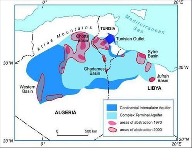
Figure 3.The aquifer system of the Béchar region.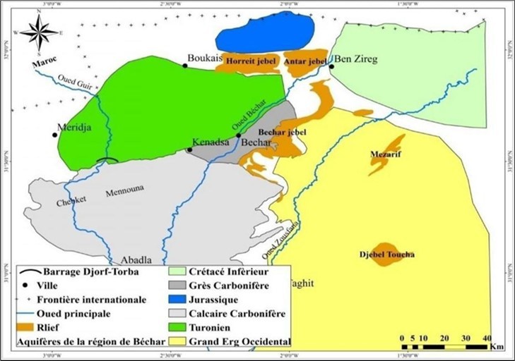
Aquifer system in the Béchar region
The region of Béchar is located in the South-West of Algeria, constituted by its geographical extension over an area of more than 90,000 km2. An arid zone where there is a situation of water stress.Groundwater is a major economic resource. The region is made up of aquifer systems, containing a number of very interesting aquifers from a quantitative and qualitative point of view, based on geological and hydrogeological arguments, a delimitation of the various aquifers is represented on the map below (Figure 3). In the study area, the aquifer system can be classified into two groups. The Turonian and Carboniferous limestone aquifers, which for their extent and thickness can be considered the most important regional aquifers, belong to the first group. The other aquifers, belonging to the second group, are considered to be of minor internet for local character, such as the Inferoflow aquifers of the Quaternary, of the continental terminal and that of the Carboniferous sandstones.
At the level of the Béchar region, we find that a region belongs to a large hydrogeological entity. The stratigraphic position and distribution of potentially aquiferous terrain existing in the study area breaks down as follows:
Carboniferous limestone aquifer
Lower Namurian carbonate formations are present throughout the western sector of the study area. The aquifers include the lower Namurian limestones of the western slope of the great submeridian Carboniferous Zousfana anticline and the Mennouna-Djenian anticline.
Carboniferous Sandstone Aquifer
Groundwater can be found either in the altered part of the sandstone-marly terrain, or in the fractured zones of these quartzites from the Upper Middle Namurian, Westphalian and Stephanian. These aquifers were studied in the area between Djebel Béchar and Kénadsa. The term "Carboniferous sandstone" defines the sandstone-marly formations with rare intercalations of limestone and quartzitic sandstone from the Middle-Upper Namurian, Westphalian and Stephanian.
Mougheul Jurassic Aquifer
The Mougheul catching field, located to the north (70 km) from the town of Béchar. Jurassic dolomitic limestone outcrops largely to the north and northwest on the flanks of Djebel Grouz, and extends to the Ben Zireg region. Several water points solicit this tablecloth, the source of Ain-Merah constitutes one of its outlets; three boreholes from 150 to 180 m gave a flow rate of 30 l/s. According to the correlation between the water points were carried out in the zone of Moughle (Figure 4-6-b) and on the basis of the analyzes of the maps one can conclude that the area contains only one geological horizon which can constitute probably an aquifer is the Jurassic formation.
Turonian limestone aquifer
The Turonian aquifer concerns the entire North-West sector of our study region. This aquifer belongs to the Cretaceous basin of Er Rachidia-Béchar. It constitutes the first underground water resource in terms of importance and exploitation, providing 20% of drinking water supply for a local population estimated at more than 192,900. The water from this sheet circulates in the aquifer. Limestone of the Béchar-Kénadsa basin approximately (4000 km2), which represents the eastern sector of the large Cretaceous basin of Boudenib (800 km2). This basin is delimited to the north by the South Atlas accident, to the south by the Turonian cliff, to the east it closes between the Telzaza massif and the Djebel Béchar around Ben Zireg. To the west, the basin thins out into a narrow furrow that reaches its minimum width at Tinerhir 32, 20.
Continental Terminal groundwater
The Continental Terminal aquifers are located in the limestone aquifer of the Upper Eocene existing in the North-West of the Béchar region and in the Hamadian terrains to the West, outside the study region of (Hamada de Guir). By the term Continental Terminal, we define the Tertiary continental successions which seal the basin of Béchar-Kénadsa and which constitute the Hamada du Guir.
Tindouf region aquifer system
The Wilaya of Tindouf is located in the southwest of the national territory. Its wilaya capital is located about 2000 km from Algiers. It is bordered to the east by the Wilaya of Adrar, to the north-east by the Wilaya of Béchar, to the west by Morocco and the Sahrawi Arab Democratic Republic and to the south-west by Mauritania. The Tindouf region is part of the desert climate zones, characterized by an annual precipitation of around 50 mm and an average temperature equal to 24°C (the hottest month with a temperature of 45°C, is that of July, and the coldest corresponds to the month of January with an average temperature of around 5° C).
The Tindouf syncline, better known in the literature as the Tindouf basin, whose surface is approximately 200,000 km2. The flow rate of the boreholes in the catchment field which supply the municipality of Tindouf with drinking water is 119 l/s (source, Algerian water).
With a new production of 20 l/s, we need to drill 6 boreholes in the Hassi Abdelallah locality with a depth of 120 m to 130 m. to arrive at 231 l/s. This quantity c will be treated by the Demineralization station. From the hydrogeological point of view, six (06) geological formations are likely to be aquifers, these have been highlighted from the boreholes capturing and exploiting these aquifers (Figure 4). It is :
Figure 4.Schematic hydrogeological map showing the distribution of the different aquifer levels and the favorable zones for drilling through the territory of the Wilaya of Tindouf.
Hamadian aquifer (from the continental Tertiary)
The Hamadiènne aquifer located in permeable soils extends to near the foot of the Anti-Atlas chain. The Hamadian aquifer whose hydrographic network is made up of a series of endorheic basins, which includes the large sebkha of Tindouf, the small sebkha Abdallah, the sebkha of Ain el Barka in the N-E sector and by other smaller sebkhas. The Hamadian terrains are represented less clayey with sometimes clayey conglomerates at the base and on the roof of the dolomitic limestone slabs. The thickness of the formation lithology in the Sebkha Abdellah area can reach ten meters. The impermeable bed is normally made up of Namuro-Westphalian clays and sandy clays or in general from the Paleozoic, sometimes the permeable terrains of the Hamada are in hydraulic contact with the underlying layers of the Upper Visean.
Upper Visean limestone aquifer
The water resources linked to the limestone layers of the Upper Visean constitute the most important water reservoirs in the region, with the Combro-Ordovician sandstones, put into operation for the first time in 1956 (SONAREM report). The Upper Visean aquifer is composed of limestone, clay, dolomite, evaporite; The thickness of this formation in the sebkha Abdallah area is 400 m and increases towards the north where it is captured by nine (09) boreholes.
Lower Devonian sandstone
The course of outcrop of the sandstones constitutes by a strip of a few kilometers wide is approximately oriented east-west. These sandstones are limited to the roof, by clays from the Middle and Upper Devonian and to the wall, by clays from the Sebkha Mabbes formation, from the Gothlandian. The thickness of the sandstones decreases from west to east, going from about 100 to 50 m.
Cambro – Ordovician sandstone nappe
The Cambro-Ordovician sandstone outcrop (Rhezziane formation) consists of an ENE-WSW oriented band, a few kilometers wide and approximately a few hundred kilometers long. The formation of rhezziane consists of three sandstone levels whose thickness can vary from 0-60 m. This aquifer consists mainly of sandstone and quartzitic sandstone.
N.B:
The Lower Devonian and Cambro-Ordovician sandstones are only visible in the southern part of the Wilaya, at Gara Djebilet and at Aouinet Legraa, where they form a strip several kilometers wide by a few hundred kilometers long oriented ENE- WSW thus constituting the southern flank of the Synclinal of Tindouf. These sandstones plunge deeply towards the locality and the immediate surroundings of Tindouf.
The Infracambrian aquifer
This aquifer is made up of sandstone, limestone, dolomites and clays.
Hydrogeological summary of the Tindouf region
A regional hydrogeological study was carried out from 1975 to 1977 by SONAREM in the area between Gara Djebilet and Aouinet Legraa (Idrotecneco, 1978), this regional hydrogeological study made it possible to highlight the following land likely to be aquifers. Table 1
Table 1. Main aquifers of the Tindouf basin.| Study zone | - Hamada | - Quaternary | - | 20 à 60 |
| SEBKHA ABDELLAH | - Sandstone, marl | - Namurian | 15 à 25 | 15 à 30 |
| - Limestones | - Upper Visean | 25 à 50 | 20 à 100 | |
| - Limestone, sandstone | - Lower Visean | 70 à 180 | 180 | |
| HAMADED AROUEIDA | - Hamada | - Tertiary - Quaternary | - | 30 à 60 |
| - Sandstone, marl | - Namurian | 40 à 50 | 30 à 40 | |
| - Limestones | - Upper Visean | 20 à 60 | 20 à 50 | |
| - Limestone, sanstone | - Lower Visean | 40 à 160 | 70 à 160 | |
| GARA DJEBILET | - Alluvia | - Quaternary | - | 4 à 6 |
| - Sandstone | - Devonian | 0 à 50 | 15 à 120 | |
| - Sandstone | - Ordovician | 0 à 30 | 35 à 60 |
From a qualitative point of view, the mineralization of the waters of the Tindouf region can reach 2710 mg/l, the most charged areas are located in Hassi Abdelah. Zones of medium mineralization are generally located north of Tindouf. The lowest value was found at borehole GC 02 at Ghar djebilet, 680 mg/l. So in most of the waters analyzed in the wilaya of Tindouf the mineralization is less than 2000 mg/l or 87% of the samples analyzed 3. It can also be seen that the waters of this region are characterized by a high hardness 96% exceeds 50°F. the fluorine values in the waters of this region show a slight excess which can reach a level of 3.31 mg/l. 35% of the water analyzed exceeds the tolerable concentration of 2 mg/l (Figure 5).
Figure 5.Map of Fluorine contents in the Tindouf region.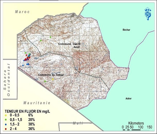
Tanezrouft Basin Aquifer System
Indeed, in the Tanezrouft basin located in southwestern Algeria (Figure 6), one of the main cross- border basins that is poorly known and poorly exploited in Africa. The Tanezrouft basin covers the part of the Sahara lying south of the Tademait plateau, of which Reggan is at the southwestern end and bounded to the west by Erg Chech and to the east by the Hoggar and of the Iforas of Adrar. The Tanezrouft basin is part of the set of Iullemeden (SAI) and Taoudéni/Tanezrouft (SAT) aquifer systems covering an area of approximately 2.5 million km² and spanning seven countries: Algeria, Benin, Burkina Faso, Mali, Mauritania, Niger, and Nigeria. This set is characterized by two important aquifers: The Continental Intercalary at the base and the Continental Terminal at the top. The Niger River crosses the Iullemeden Aquifer System (IAS) over a length of about 700 km.
Figure 6.Situation of the Tanezrouft basin.
The hydrogeological study of the continental formations which rest directly on the pre-Mesozoic terrains are of Lower Cretaceous age. The thickness of this intercalary continental is variable, it reaches 200 to 250 m on the plateau of Tanezrouft. It can reach 600 m further south (beyond the Algerian-Malian border).
The Tanezrouft basin, the aquifer, contains an aquifer, located in the continental intercalary sandstones belonging to the Upper Cretaceous series, with a flow rate of 38,000 cubic meters per day (m3/d), for a limited studied surface of 8000 km². This aquifer is characterized by an estimated water resource of around 1.1*108 m3 and an exploitable reserve for a period of 25-30 years of around 8,000 m3/d.
Aquifer system in the Beni-Abbes region
The Saoura basin is part of the great watershed of the Sahara. It is located in the southwest of the Algerian territory and occupies an area of about 100,000 km². The basin is made up of four sub- basins of different sizes. They are drained by streams descending from the Moroccan Atlas and the Saharan Atlas and flow from North to South (Figure 7).
Figure 7.Location of the Béni Abbés Oasis in the Saoura Valley
The Saoura is known by its wadi, which begins at Igli, the point of confluence between the Guir and the Zousfana and ends towards the South at the level of Foum El Kheneg, after a course of 250km, then, it gives birth to two wadis ; Souireg which leads the flows of the Saoura to the immense depression of Sebkha el Melah near Kerzaz. The second, known as the Messaoud wadi which flows towards the Touat depression, only after the overflow of sebkha. The Saoura wadi shows floods in Autumn and Spring. Its contributions are variable, there are contributions at the level of Béni Abbès estimated at 400 Hm3 and at 350 Hm3 at the level of Kerzaz.
Figure 8.Saoura watershed
Béni Abbès appears as the capital of the Saoura Oasis. It is located about 240 kilometers southwest of Béchar and 880 kilometers southwest of Algiers (Figure 8). The Saoura Valley, resulting from the junction of the Guir and Zouzfana wadis, represents the main watercourse of the North Western Sahara of Algeria. It is bordered to the east by the Grand Erg Occidental, and to the west by the Hamada du Guir and the small Hamada.
Groundwater is the only water supply resource for the Saoura Valley region and particularly the Beni Abbès region. At this locality, it was possible to identify four interconnected aquifers, of varying sizes. The tablecloth of the great western erg offers good water and represents the main nerve of the aquifer system, within which there is an outlet par excellence, usually called the Great Source (28 -33 l/s). The groundwater salinity problem caused by several human and natural factors, causing serious irrigation problems. In addition, the availability of drinking water exceeds the needs, however, it is requested to further develop the distribution networks. On the other hand, the needs of the palm grove are only met at 6.28%. The subsoil contains significant underground water resources. Contains an interconnected system including the Saoura valley considered as an umbilical cord (Merzougui 2007).
This system includes (Figure 9):
Figure 9.Main aquifers of the Saoura.
The Grand Erg Occidental aquifer, hydrogeologically well defined, is recharged mainly by the Namous wadi of the Saharan Atlas. The large source, known as the “source of Sidi Othmane”, represents an outlet par excellence for this aquifer, with its flow rate of 33 l/s (Merzougui, 2007). It plays a dual role, supplying drinking water to the city and irrigating the palm grove.
The Hamada du Guir aquifer, fed by rare rainwater and the Aicha and Abiod wadis, is contained in Tertiary lacustrine limestone.
The aquifers of the Paleozoic formations are only known locally, at the level of the Zéghamra and Ougarta villages, whose aquifer is the Cambrian and the Ordovician. These aquifers are partially fed by rainwater and probably by the Saoura wadi.
The aquifers of the alluvial terraces and lower flows constitute a particular aquifer system formed by the large outpourings of sand and gravel from the Saoura.
The Béni Abbès aquifer system features two lithological units: limestone and sandy marl from the MioPliocene and Quaternary formations. The MoiPliocene reservoir is composed of a succession of limestone and sandy marls of 40 m, rests directly on an impermeable Devonian substratum. In addition, the reservoir of the alluvial aquifer is constituted by a quaternary set, composed of four layers (sand, clay, sand, conglomerate) of thickness varying between 10 to 30 meters, the whole rests on an upper Devonian schistous substratum pleated. The average thickness of the alluvial aquifer is fifteen meters.
The recharge of the alluvial aquifer of the palm groves of the Saoura valley is ensured by a natural drain by the inflow of water from the Grand erg aquifer on the one hand, and on the other hand by the infiltration of irrigation water and wells and occasionally by the floods of the Saoura wadi.
Aquifer of the Grand Erg Occidental
This aquifer is the most important and the largest aquifer reserve in the Saoura valley, limited to the north by the South Atlas flexure. It extends to the North - East to the country of the Daias (North of Ghardaia) The piezometric map shows flows from the North to the South, that is to say from the Atlas to the Saharan platform: the Saoura and the Gourara -Touat. 30, 24 (Cornet, 1964) (Figure 10). This aquifer is essentially fed by the northern wadis to which are added the infiltration of meteoric waters into the sands and floods at the level of Jebel El Kehla (Schoeller, 1962 )29.
The name of the tablecloth of the great western erg seems to us to be inappropriate. It is not in the sands of the erg that the water circulates but in the Mio-Pliocene formations that it covers. TheHamadian sil-cocalcareous slab constitutes a preferential medium for the circulation of water. The great source of Béni Abbés constitutes the outlet par excellence of the Erg aquifer to the right of Béni-Abbés, this source usually called "Ain Sidi Othmane" being itself linked to this environment, litho stratigraphic conditions and particular structural features that were defined by the geophysical study 24 ordered a gathering of the waters at its level.
Figure 10.Piezometric map of the Grand Erg Occidental aquifer (Merzougui,2021).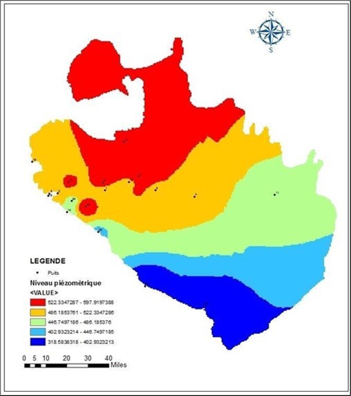
Feed
The aquifer of the great western erg is fed from the wadis of the Saharan Atlas (wadi Namous and wadi Gharbi). We are now in 2023 and eighty-one years after Schoeller's first research in 1942, we are forced to note that our knowledge of the physics of the aquifer of the Oran South Hamada has hardly progressed.
The Hamada du Guir aquifer
The Hamada is located on the right bank of the Saoura valley, it is a slightly inclined plateau, from Boudenibe (1150m) to the Ougarta chains (650m) with a width of 110 km and a length of 200 km. The plateau is oriented NW-SE, the limestones constitute the aquifer, whose recharge is complex, ensured on the one hand, by the wet periods of the quaternary, on the other hand, by a system of wadis (wadis aicha, wadi El Abiod, Wadi Alarfedj). This sheet shows a general flow following the elongation of the Hamada NW-SE. 10.
Aquifers of the terraces and inferoflows of the Saoura Valley.
The lower flow of the Saoura valley constitutes the base level of groundwater. This level is fed by the floods of the Saoura wadi, which seeps into the sands of its bed, along the Saoura valley. The depth of the piezometric level generally varies from zero (Guelta) to three meters below the ground. The hydraulic gradient of the lower flow can be assimilated on a small scale to the slope of the longitudinal profile of the Saoura valley. It is 0.65/1000 from Marhouma to Sebkha el Melah 29.
Groundwater, a common heritage that urgently needs to be protected
We can cite four principles for achieving preservation of groundwater as an essential heritage and key to development, namely:
The first principle insists on the improvement of hydrogeological knowledge and shared representations of the functioning of aquifers;
The second principle proposes setting up processes for sharing knowledge and consultation between uses;
The third principle recommends relying on communities of users to share responsibilities;
The fourth principle, finally, encourages the understanding of groundwater as a common heritage and the development of territorial projects allowing the establishment of legitimate regulatory instruments at the local level;
Conclusions and recommendations
In the Sahara, the aquifers, which are among the largest in the world, remain largely under-exploited. They therefore constitute a considerable potential, provided that sustainable management of these resources is adopted.
It should be noted that 96% of the fresh water on the planet is found in underground aquifers, Aquifers, which represent a volume 100 times greater than fresh surface water, already provide a good part of our needs. The increase in the demand for water has resulted since the second half of the 20th century in a growing use of these underground basins.
Globally, this resource is used 65% for irrigation, 25% for drinking water supply and 10% for industry.
This note is part of a general strategy to share information and knowledge on groundwater resources in the south-west of the country in an arid to hyper-arid region, in this case the Western Sahara region of the country. Algeria, on the geological, hydro-geological aspects of this source. It is therefore a contribution, characterizing the aquifer system from a structural point of view, its hydrodynamic functioning, the quality of the waters it contains and evoking the predispositions to pollution. The south-west of Algeria, including the Saoura, belongs to the world of the Algerian Sahara, strongly enclosed in the Saoura valley, a famous geographical entity in the south-west of Algeria. This entity is adorned with verdant oases, transformed deep into real modern cities, including that of Béni Abbès considered to be a capital.
At the end of this modest work it appears that the drinking water supply of the population of four wilayas is carried out especially the new wilaya Beni Abbes in the process of development according to three hypotheses:
a transfer from the Cambro-Ordovician nappe or Hamada de Guir
transfer from the large western erg aquifer.
transfer from the Cretaceous.
The sustainability of key systems of sustainable development unequivocally requires the regulation of all entropic actions in the soil and or subsoil, including the Grande Source should be developed and delimited by an immediate protection perimeter. This source can be qualified as a pilot area for future study to better understand the quantitative and qualitative evolution of the Mioplio- Qauternary system of the Saoura.
An in-depth hydrogeological study of the various aquifers, especially at the local level - very interesting, using the various geophysical methods.
A rehabilitation and valorization of the ingenious system of the foggaras is necessary, the latter allow a good mobilization of the regulating reserve of the water resource up to our days.
Mapping of potential aquifer recharge in arid and hyper-arid zones: application to the Saoura, Gourara, Tanezrouft and Tindouf aquifer systems.
Detailed study of all the hydraulic structures located on the left bank of the Saoura to provide information on the effect of the groundwater discharge, and to arrive at an estimate of the flows passing through the lower flow of the Saoura.
Recovery and treatment by desalination (membrane filtration) of brackish water from lower flows.
Climatological study of daily precipitation to estimate current point recharges on the Paleozoic aquifer and the Erg aquifer as well as on the entire Sahara basin, especially the Saoura side.
The installation of gauging stations to estimate and control the flows from Oued Saoura to Igli, Beni Abbes, Kerzaaz, Daoura, Oued Namous, and Sebkhet el Mellah.
The implementation of a pilot project of the aquifer contract at the level of Béni-Abbès.
Updating of isotopic studies of the waters of the Saoura
Hydrogeological modeling of the Mio Plio-Quaternary aquifer of the great Western Erg of Saoura.
References
- 1.AMRANE T, AYAD A. (2011) Summary report (geology, hydrogeology, geophysical surveys, drilling and piezometers) of the Tindouf basin. Hydraulic Department – operating department.
- 4.Alimen H. (1957) Tertiary and Villafranchian in the North-Western Sahara. , C R .Soc Geol Fr 238-40.
- 5.Baba Hamed K, Bouanani A, Terfous A. (2005) Transitional model of the alluvial plain of the Hennaya plain (Tlemcen, NW-Algeria) the water and environment journal. , ENSH Blida 7, 17.
- 6.Conrad G. (1969) The post-Hercynian continental evolution of the Algerian Sahara (Saoura, Erg Chech-Tanezrouft, Ahnet-Mouydir). Paris: Center for Research on Arid Zones, geology series. , CNRS; 10, 527.
- 7.Conrad G, J C Fontes. (1970) Isotopic hydrology of North-Western Sahara. "Isotope Hydrology. , A.l.E.A., Proceed. Symp. Vienna 405-419.
- 8.Cornet A. (1962) Essay on the hydrogeology of the Grand Erg Occidental and neighboring regions. The foggaras. Trav Inst Rech Sah. , VII: 71-122.
- 10.Combes M. (1966) Hydrogeological study of the Guir hamada. Municipality of Bechar Dept. From the Saoura. S.E.S. study : 68/DH.1M.1’I/C.de la circums.des T.P.H.Des Oasis et de la Saoura, 8 survey sheets, 4pl 14.
- 11.Dubief J. (1960) The climate of the Sahara Tome I. Univers. Algiers, inst. search Sahara. , published by C.N.R.S. , Paris
- 12.Fabre J. (1975) Introduction to the geology of the Algerian Sahara.-. , Ed. SNED, Algiers 422, p..
- 14.Haddou k, Bensalem S. State University of Oran (2004) Hydrogeological contribution to the study of the water quality of the Béni Abbès aquifers Memory ing. 65.
- 15.Lachache S. (2018) Contribution of GIS in the integrated management of water resources in the region of Béchar (South-West Algeria). LMD doctoral thesis, Univ. Tahri Med Bechar.217p. 166 fig .
- 16.Mansour H, Safa A, Bekhedda B. (1998) The South Atlas flexure and its hydrodynamic role in the recharge of the Saharan platform at Beni Ounif. Study days on arid zones, retrospectives, issues and realities. , Adrar
- 17.Mekideche D, Touat S Sain, Younsi N. (1995) Hydrogeological map of the Béchar region. Explanatory note. 73.
- 18.N Alimen Menchikoff, H LE Maitre, Petter D, Poueyto G, A. (1952) The Ougarta and Saoura chains. 19th Congress. , Algeria, Geol. Inter., Algiers, Mongr. Region 1.
- 19.Abderrahmane MEKKAOUI. (2015) Geochemistry The basic magmatism of the Damrane-Kahal axis Tabelbala (Daoura, Ougarta Mountains, South-West, Algeria): Geology, Petrology, Geochemistry and Context Geodynamics. THESIS Doctorate in Sciences; University of Oran 2 Faculty of Sciences of the Earth and the Universe; 232 P, Plate 14 .
- 20.Mekideche D Sai, S N Touat, Younsi N. (1995) Hydrogeological map of the Béchar region. Internal report, explanatory note. , DHWB, Béchar, Algeria 74, p..
- 21.Merzougui T. (2011) Hydrogeological characterization and hydrodynamic modeling of a alluvial aquifer in a hyper-arid zone: case of the palm grove of Béni Abbés (Saoura Valley, south-west Algeria), Memoir of Magister; Abou Bekr Belkaid University of Tlem-cen. 145.
- 22.Merzougui T. (1998) Valuation of water resources in the upper Saoura Valley (between Taghit and Kerzaz) State Ing memoir, Univ d'Oran Algeria. 175, p..
- 23.Laurence Chery, Marsily Ghislain. (2007) Aquifer systems management: Darcy's legacy in a world of impending water Shortage, edition Tayor and Francis Chapter 20. 269-279.
- 24.Merzougui T. (2021) Structure and functioning of an aquifer system in hyper-arid zone: Application of the Béni Abbés region (Saoura Valley, South-West Algeria). Doctoral thesis in science. Univ. Tlemcen. 350p
- 25.OSS. () Northern Sahara Aquifer System. Volume 2: Hydrogeology. SASS project. , Tunis, Tunisia, Internal report. Cuts. Boards. Appendices
- 26.OSS. () Northern Sahara Aquifer System. Volume 4: Mathematical Model. Project SASS; Internal report. Appendices. , Tunis, Tunisia
- 27.Baba Oueld.Sy Mouhamed (2005). Recharge and paleo recharge of the Sahara aquifer system northern. Doctoral thesis in geology. Univ. El Manar Tunis. 271.
- 28.Roche M A. (1973) Hydrogeology of Haute Saoura (North-Western Sahara). Paris: Publ CNRS, Geol series;. 91.
- 29.Scholler H. (1945) The hydrogeology of part of the Saoura valley and the great western erg, bull, soc, geol.fr.5.T.XV. 563-585.